Private Institute for Climate Change Research, Guatemala. The Private Institute for Climate Change Research ICC has started the first hydrogeological regional study in the Guatemalan Pacific Basin.
The scarcity of water during the last months of the dry season in the last years has shown the importance of integrated management for the water resources sustainability. Scarcity events can be expected to increase in intensity as a result of climate change (MARN, 2015).
Groundwater is a key component of the water cycle for vulnerability reduction to drought events. The spatially scattered population in this rural region makes a centralized piped water supply system unfeasible. Hence, rural population water source is mainly groundwater coming from domestic dug wells. On the other hand, most high-density populated areas have a piped supply network coming from drilled deep wells. Previous studies in the region indicate that the percentage of domestic water relying on groundwater is higher than 85% (IAI, 2015). Furthermore, the agricultural activities in the region also require sources of water, such as dug or drilled wells, to provide irrigation during the dry season.
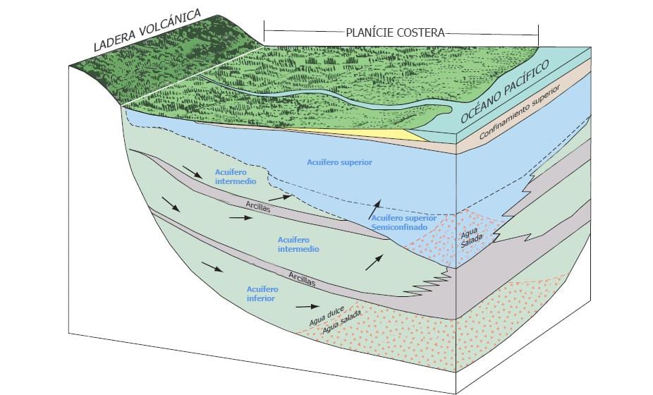
A well understanding of groundwater systems is the first step towards an appropriate sustainable management. The common belief in the area is that groundwater flows like subterranean rivers forming a channel network. However, the Pacific basin has a geologic volcano-sedimentary origin, and the groundwater flows through a continuous porous media, generally from higher towards lower lands.
Figure 1. Coastal aquifer system conceptual model example.
Source: Adapted from Williams, L.J., and Kuniansky E.L. 2016.
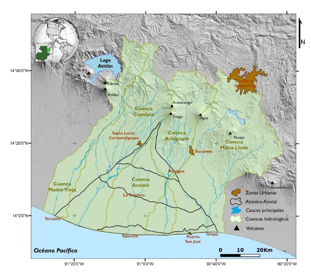
The objective of this research is to generate a conceptual model of the groundwater systems of Fuego Volcano alluvial fan. The study area is a volcano-sedimentary physiographic unit located in Escuintla Province. It is a territory between the river basins of Achiguate, Acomé, Coyolate and María Linda. Agriculture is the main land use, occupying a 91% of the 2.185km2 (MAGA, 2010). The population on the study area is higher than 300.000 inhabitants, with important populated areas such as Santa Lucía Cotzumalguapa, La Gomera, Siquinalá, Puerto San José, Masagua and La Nueva Concepción (INE,2013).
Figure 2. Study area location: Fuego volcano aluvial fan. Source: Adapted from IGN, 2000.
Part of this research will be done as a Master Thesis project by Sergio Gil Villalba, associated researcher of ICC. Academic supervisors from Instituto Superior Técnico de Lisboa (Portugal) and IHE Delft Institute for Water Education (the Netherlands) will assess and provide guidance for the research. From ICC, the hydrogeologist Romy David and the junior researcher Erick Alvarado are providing support in the execution of the fieldwork and interpretation of the results.
Fieldwork is being carried out during April and May and it includes two activities:
- Geophysics: Vertical Electrical Soundings will allow the identification of the hydrogeological units where water is flowing.
- Hydrochemistry: to understand the groundwater flow systems, identify recharge and discharge areas and understand local and regional groundwater flows.
It is expected that this research project will validate this methodology in the area in order to replicate it in other areas of the Pacific Basin.
References:
IAI, 2015. Encuesta para conocer la influencia de los eventos de variación climática en los medios de vida de la población del Municipio de Nueva Concepción Cuenca del Rio Coyolate. Community Resilience Assessment to flood and drought events in the Coyolate basin (Guatemala). Pontificia Universidad Javeriana, Facultad de estudios ambientales y rurales (Bogotá, Colombia). ICC- Instituto Privado de investigación sobre Cambio Climático (Guatemala). Universidad Nacional de Tucumán – Instituto de Ecología Regional (Argentina). Universidad Mayor de San Andrés (UMSA – Bolivia), American Institute for Global Change Research (IAI).
IGN, 2000. Mapa fisiográfico geomorfológico. Instituto Geográfico Nacional. Gobierno de Guatemala.
INE 2013. Caracterización Departamental de Escuintla. Instituto Nacional de Estadística. Gobierno de Guatemala.
MARN, 2015. Cambio Climático: Riesgo de sequía e inseguridad alimentaria. Boletín informativo: marzo 2015. Ministerio de Ambiente y Recursos Naturales. Gobierno de Guatemala.
MAGA 2010. Mapa de Cobertura Vegetal y Uso de la Tierra a escala 1:50,000 de la República de Guatemala, año 2010. Ministerio de Agricultura, Ganadería y Alimentación. Gobierno de Guatemala.
Williams, L.J., and Kuniansky, E.L., 2016, Revised hydrogeologic framework of the Floridan aquifer system in Florida and parts of Georgia, Alabama, and South Carolina (ver 1.1, March 2016): U.S. Geological Survey Professional Paper 1807, 140 p., 23 pls, http://dx.doi.org/10.3133/pp1807


